Support Us Button Widget

How walkable are Nashville’s neighborhoods?

This interactive map can help you determine how walkable certain blocks are to destinations like supermarkets, parks, restaurants, and schools.

An aerial view of Bicentennial Capitol Mall State Park.

We took a look at just how walkable a block of Germantown is. | Photo by @monkeytrent

How walkable is Nashville, really?

Let’s say you’re looking to buy a new home in a neighborhood that you’re not completely familiar with. Or perhaps you have family members trying to figure out what’s near that local Airbnb they’re visiting soon.

An interactive map called “Close” helps determine if you can walk to specific destinations like supermarkets, parks, coffee shops, and schools in Nashville — and how long those walks will take.

A local look

In this example, we’re looking at a block of Germantown — lauded as one of Nashville’s most walkable neighborhoods — between Taylor and Monroe streets. We chose to look at this block’s distance from five destination types:

  • Parks | <5 minutes
  • Supermarkets | 9 minutes
  • Coffee shops | <5 minutes
  • Libraries | 11 minutes
  • Public schools | 21 minutes

You can also add a number of other destinations like public transit stops, restaurants, bars, and gyms.
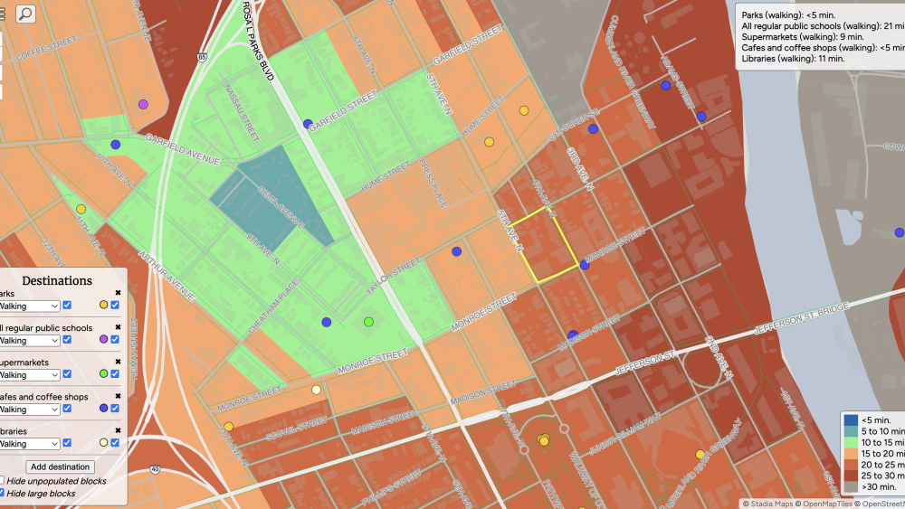
A map of a part of Nashville, with one small block outlined in yellow. In three of the four corners is a map legend describing what the map says.

Map users can select which block or area they’re curious about — once selected, the block will be outlined in yellow. | Screenshot via Close

Try it yourself

Want to use it yourself? First, decide which destinations you’d like to focus on — you can choose these in the bottom left-hand corner of the map.

Once you’ve set the destinations you’re interested in, use the search bar to choose a city. Zoom in on specific areas or neighborhoods, then click to select a particular block.

Once a block has been selected, the information will pop up on the top right-hand corner of the screen; while we chose to only look at walkability in our example, the map can also determine distance via public transit.

Wondering how else you can learn about local neighborhoods? Check out our articles about NASH neighborhoods as drinks, the history of street names, and more via our City Guides.

More from NASHtoday
The store finds vacant retail spaces and signs temporary leases to set up shop leading up to Halloween — but locations can change each year.
Not ready to log trips? You can also explore Nashville’s transit options at free events this month.
From pizza slices to movie tickets, here’s how to picture Nashville’s record tourism spending.
Bookmark this guide for a curated list of events taking place each month that we’re most looking forward to.
Fall festival season in Nashville, Tennessee is right around the corner. Add these local events to your calendar to stay busy until the leaves are no longer crunchy.
Football is back. Here’s how to get to the games, tailgate like a pro, and cheer on the Tennessee Titans this 2025 NFL season.
“For decades, this space has fostered creativity and focus, allowing artists to escape the hustle and bustle of everyday life,” the listing reads.
After decades as a scrapyard, this 45-acre East Bank site has sold and is primed for redevelopment — what would you want to see there?
No boat? No problem. Rent one Airbnb-style and start enjoying our local waterways.
The 2025 Inc. 5000 list is here, and we’re breaking down Metro’s total growth, as well as meeting some of the Nashville-based and regional businesses that made the cut this year.